
El Niño and La Niña are opposite recurring phases in a natural Pacific Ocean cycle called the El Niño–Southern Oscillation (ENSO). Because the ENSO affects the entire tropical atmosphere, these phases have far-reaching effects that shape weather patterns around the world.
Although the ENSO has been cycling for at least thousands of years, climate change has recently amplified the impacts of both El Niño and La Niña. Understanding how these phases work and influence global weather can help communities plan for the future.
What is the El Niño-Southern Oscillation (ENSO) cycle?
The ENSO is a naturally occurring cycle in the tropical Pacific Ocean that moves between El Niño, La Niña, and normal conditions. The movement of heat in the Pacific Ocean and the atmosphere drives the ENSO cycle. These swings usually occur every two to seven years, with each period lasting nine to 12 months. Most of the impacts of El Niño and La Niña occur during the winter months, disrupting weather patterns worldwide.
Normal conditions
Under normal conditions, steady Pacific temperatures keep conditions stable, with trade winds blowing steadily from east to west, pushing warm surface water toward countries like Indonesia and Australia. This warm water gathers in the western Pacific warm pool, the warmest large area of ocean on Earth, where it heats the air above it, causing it to rise and form clouds and rainfall that drive the western tropical Pacific’s predictable rainy seasons. As warm water is pushed westward, cold water rises to the surface in the eastern Pacific; the cooler surface keeps the air above it from rising and forming clouds, contributing to the dry climates and deserts of countries like Peru and northern Chile.
Conditions can shift into the El Niño or La Niña phase of the ENSO cycle when the usual balance between Pacific winds and ocean temperatures changes. Changes in the Pacific winds and ocean temperature influence each other, meaning that disruption can amplify change. For example, if trade winds weaken or strengthen, or if warm water spreads differently across the basin, those shifts can set off a chain reaction that steers the system towards either El Niño or La Niña.
El Niño
El Niño boosts global temperatures and increases the likelihood of heavy precipitation in parts of the United States, South America, and Africa, and drought in regions such as Australia, Indonesia, South Asia, and other parts of Africa and South America. El Niño usually suppresses hurricane activity in the Atlantic and increases hurricane activity in the Northeast Pacific.
During an El Niño phase, the usual temperature contrast between the western and eastern Pacific narrows. This can happen because the trade winds weaken or reverse, or because changes in ocean temperature weaken them. When that balance shifts, the air pressure gradient over the Pacific also drops, which makes the trade winds slow down even more.
With weaker trade winds, warm water that normally piles up in the west spreads and pools in the eastern Pacific near the Americas. This change warms the air above it, reduces cold-water upwelling, and disrupts normal ocean currents, shifting atmospheric circulation so that storms and rainfall form farther east than usual. As a result, places like Peru and Ecuador become wetter, while regions such as Indonesia and Australia become drier. In North America, the jet stream shifts south during El Niño, steering more storms into the southern United States and leaving northern parts of the U.S. warmer and drier.
As El Niño continues, the warm water that has spread east gradually depletes the heat stored in the western Pacific, weakening the pattern that sustains El Niño and allowing the system to move back toward neutral or into La Niña.
La Niña
La Niña increases the likelihood of increased precipitation in many regions, including Southeast Asia, Australia, parts of South America, and the U.S., as well as increased hurricane activity and intensity in the Atlantic basin.
La Niña can develop when trade winds become stronger than normal, or when unusually cold water appears in the eastern Pacific, increasing the ocean temperature contrast between the warm western Pacific and the cool eastern Pacific and creating higher atmospheric pressure over the ocean. These stronger trade winds enhance cold-water upwelling in the eastern Pacific and push warm surface waters even farther west, where they accumulate in the far western Pacific, warm the air above them, and shift atmospheric circulation, causing storms and rainfall to form farther west.
During La Niña, the stronger-than-normal winds push warm water so far west that the temperature contrast between the warm western Pacific and the cool eastern Pacific eventually peaks, weakening the winds and allowing the built-up warm water to begin shifting back east, moving the system toward neutral or El Niño.
Global impacts of El Niño and La Niña in a changing climate
Climate change doesn’t appear to alter how the ENSO works or the timing of its cycles; it amplifies its impacts, which depend on air and ocean temperature. As global temperatures rise, oceans warm and the atmosphere holds more moisture, increasing humidity and evaporation. Higher ocean temperatures mean El Niño now builds on top of already warmer waters, which can intensify the droughts, heavy precipitation, and hurricanes that El Niño and La Niña already produce.
Climate change is also reshaping how heat is distributed in the oceans, as shifting winds and currents move excess warmth into some regions while meltwater and regional cooling leave others relatively colder. These sharper temperature contrasts disrupt trade winds and currents, and, in turn, the weather patterns that the ENSO influences, contributing to more extreme conditions during El Niño and La Niña events, such as stronger droughts, heavier rainfall and flooding, intensified storms, and more pronounced shifts in global temperature and precipitation patterns.
El Niño’s Global Impacts
- Peru, Ecuador, the Southern U.S., and East Africa get wetter.
- Indonesia, Papua New Guinea, Australia, Southern Africa, and northern South America get drier.
- Temperatures rise worldwide, with pronounced warming in Australia, Southeast Asia, and Western North America.
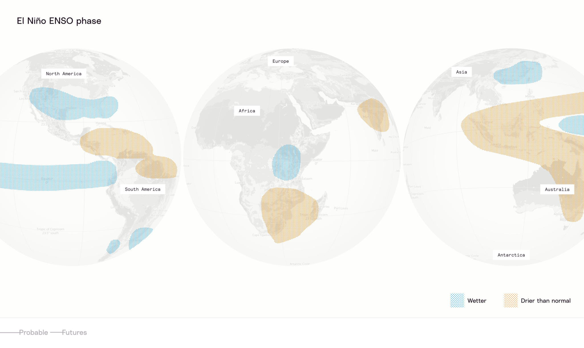
This map shows where El Niño makes weather conditions wetter or drier than normal.
La Niña’s Global Impacts
- Indonesia, Papua New Guinea, northern Australia, the northern U.S., Canada, East Africa, and parts of Southeast Asia get wetter.
- Peru, Ecuador, Chile, the Southern U.S., southern South America, and Southern Africa get drier.
- The Southern U.S., South America, and parts of Australia get hotter.
- Hurricane activity in the Atlantic basin intensifies.
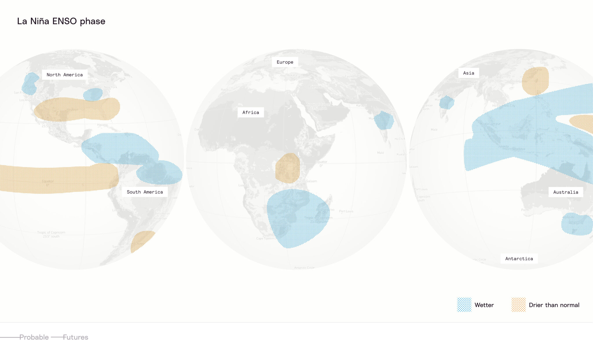
This map shows where La Niña makes weather conditions wetter or drier than normal.
The future of the ENSO
As of 2026, the world has warmed by about 1.5°C above preindustrial averages, and Pacific temperatures are about 2°C warmer in the ENSO-monitoring regions near the equator. That additional heat is interacting with the ENSO in ways that make each swing of the cycle more consequential.
Higher temperatures could lead to rapid shifts in rainfall patterns, resulting in severe drought in western Pacific countries, flooding in eastern Pacific countries, and new global heat records. Some forecasts indicate a high likelihood of a “super” or extreme El Niño developing in 2026-2027. Super El Niño events occurred in 1972–73, 1982–83, and 1997–98, with the 1997–98 episode driving record global temperatures along with widespread droughts, floods, and fires. Climate models accurately forecasted that the 2015–16 El Niño could reach similar strength, as it unfolded atop already volatile, climate‑driven weather patterns at a time when 2014 and 2015 had become the hottest years ever recorded and the Pacific Ocean was warming at an unprecedented pace.
As the planet continues to warm, the ENSO’s historical rhythm is expected to remain the same, but its impacts could become far more extreme. Instead of causing major disruptions only during their strongest phases, El Niño and La Niña may increasingly amplify storms, droughts, and floods worldwide, turning the ENSO into a recurring source of global climate risk.
Was this article helpful?
Thank you. Your feedback helps us improve.